Recently, a company contacted Traffic Data Inc. to help collect traffic data for their upcoming research project. Most of our traffic counts focus on daily volumes, turning movement counts, and/or gap studies. This study was unique in that our client was interested in documenting vehicle merging and weaving patterns at freeway interchanges. This presented a couple of unique challenges, including identifying the best data collection points and how to document that vehicle movement.
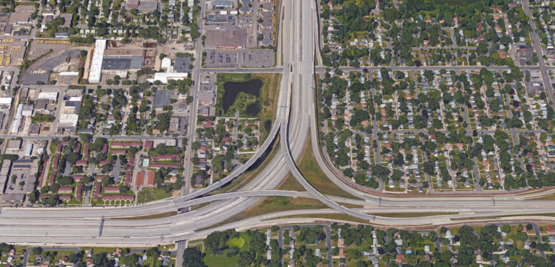
For our own studies, we almost exclusively use video to record traffic movements. For this project, video also made sense and we set cameras at several key locations around and leading up to the interchange being studied – Interstate 35W and Crosstown Highway 62 in the Minneapolis suburb of Richfield, Minnesota. Although no longer considered ‘new’, a massive four-year reconstruction project completely separated the once merging highways, including at least two through lanes for each direction of each highway along with flyover bridges, many merging/diverging points, and some dedicated exit lanes.
With interchange stretch over 1-1/2 miles, we had several discussions on the best method to obtain a good view of the traffic so our client could monitor when and how vehicles choose their lanes as they approached and traveled through the interchange. We settled on a mix of overhead and shoulder/side-view mounted locations with cameras in key spots. Overhead video cameras were set on consecutive bridges over the freeway downstream of the interchange. These top down views at multiple points along the freeway allowed the user of the videos to follow specific vehicles. Synching the clocks of the video cameras on different bridges was also a necessity to make tracking vehicles between bridges easier.
Video cameras installed on the shoulders at merging/diverging points provided a close-up views of vehicle interactions. Having the mix of overhead views off of bridges and close-up views at merging/diverging points allowed anyone viewing the videos to have a full sense of the interchange operations.
The client completed the video post processing and analysis, which included tracking vehicle movement between multiple videos as they traveled the interchange – undoubtedly a tedious counting project. Mike Spack has written about Persistent Surveillance Systems that use planes to collect video over an area and can use markers to track vehicle movement. Although definitely easier, it is a cost prohibitive solution for many agencies.
This freeway merging and weaving application is outside the normal video traffic collection process. However, it does illustrate how video can be beneficial in a wide variety of settings.
Have you collected similar traffic movements on a freeway? If so, we would love to hear from you.